Halloween came early for me this month in several ways, which I’ll explain in due course. I had set goals for my annual October road trip: Shoot peak aspen colors in Colorado’s San Juan Mountains with old friends Gordon and his brother John; explore Utah’s La Sal Mountains with my photographer friend Greg Jahn, which would be our first tandem photo safari together; photograph the Colorado River from Arizona’s Toroweap Overlook, which is the only place one can see the river from the rim of the Grand Canyon; photograph areas I hadn’t yet seen of Zion National Park and Bryce Canyon National Park; and photograph the full moon with iconic Western scenery, or at least shoot the scenery in full moonlight.
I set my own deadline to return by Halloween, as I wanted to celebrate a family member’s birthday in Boise on November 1st, and I wanted to be back home to vote early. Besides, the full “Halloween moon” would be mid-month this year, on October 16th (actually called the “Hunter’s Moon”), reducing the need for a longer road trip. October 31st would be nowhere near the peak for moonlit witching hours this year.
Saturday, Oct. 1: In the early afternoon Gordon and I drove our vehicles from his Durango cabin to John’s place in Dolores, about an hour away. We relaxed in John’s back yard and enjoyed a beer with the warm sun setting on our backs. We’ve been friends for 56 years, since we were next door neighbors in McLean, Virginia, in 1960:
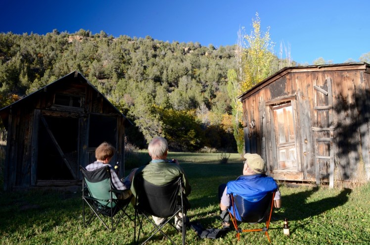
Sunday, Oct. 2: After breakfast we drove about 30 miles towards Telluride on Rte. 145 until the dirt road called Roaring Creek Road, where we headed up the mountain towards Orphan Butte, to the same free campsite that John and I had found in July 2014. We spent three nights there, and Gordon lost sleep the first night because of the coyote family that found a convenient spot a couple of hundred feet away from his tent. They had started howling at the moon, or at the colder weather, or to relatives in the distance, or for no particular reason. Gordon said they were loud, but John and I didn’t hear them from inside the camper less than 100 feet from Gordon’s tent. Normally I can hear an owl from inside my camper, but I guess John and I had fallen into a deep sleep early that night.
During our three days there we hiked a total of about 7 miles and the only other person we saw was a mountain biker. We took shots of the aspen in peak color and the clear views, which included the highest peaks of the Weminuche Wilderness about 30 miles away:


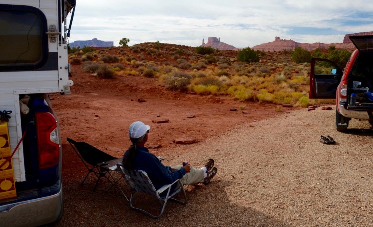
Sunday, Oct. 9: After leaving John and Gordon I arrived two hours later at Lions Park parking lot just north of Moab, Utah, to find that Greg had arrived at our designated meeting place only 15 minutes earlier. We drove east on Rte. 128 and camped at Big Hal Campground on the Colorado River the first night (see earlier post), then drove further to Fisher Towers Campground for the next night. We saw and heard motorized paragliders…


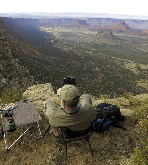
Monday, Oct. 10: We did a 4-mile “strenuous” hike around the towers and ran into rock climbers, some of whom were being monitored by a drone-mounted camera operated by a ground crew. The climbers were in precarious positions, as appropriate:


It was our first-ever encounter with an operating drone and we were put off by the noise. But we did get our exercise and some low-sun shots of the area:


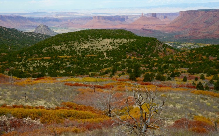
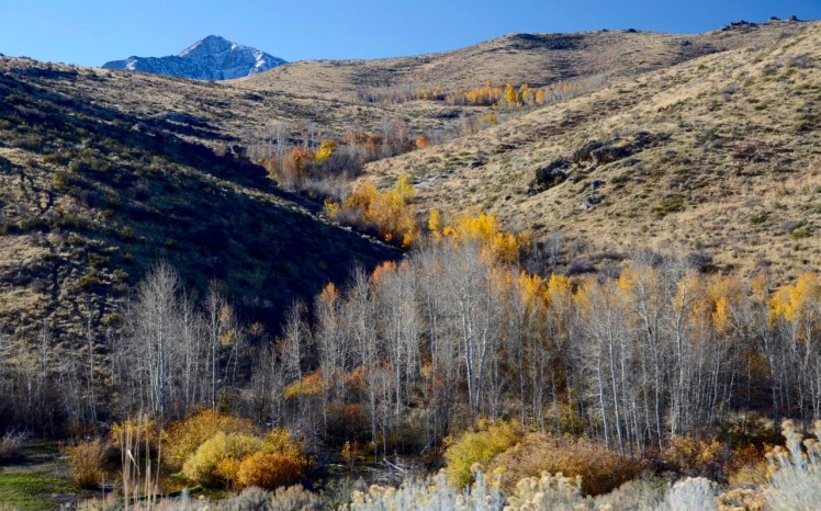
Tuesday, Oct. 11: After a relaxing morning at our pleasant Fisher Towers Campground we drove into the La Sal Mountains on the La Sal Loop Road to shoot fall colors:
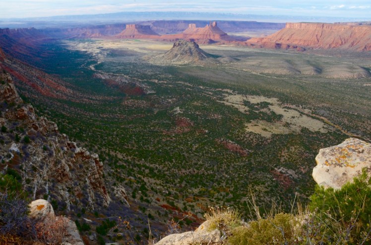
Wednesday, Oct. 12: We’d pulled into Oowah Campground in late afternoon the day before, when it was overcast with poor lighting, but this morning we did a 4-mile loop hike from the campground at about 7,500 feet and took some shots:


In the afternoon we drove down the mountain toward Moab on Sand Flats Road and found Porcupine Rim Campground, free of charge, and such a perfect perch for both sunrise and sunset shots of Castle Valley, with the welcome and wild sound of coyotes howling in the distance. Sunset that day was overcast and unexciting, so, as we sat around a campfire, we decided to stay two nights in hopes of getting better shots than these:

Thursday, Oct. 13: A cloud-free sunrise greeted us at morning coffee:


We spent a breezy, sunny day reading and hanging around camp as we waited for another sunset…
 It turned into an anxious late afternoon when the gathering clouds again obscured the setting sun. As the sun almost reached the horizon we wondered if we would get lucky this time. I was discouraged, but Greg was optimistic. In the sun’s last five minutes before disappearing, we got lucky:


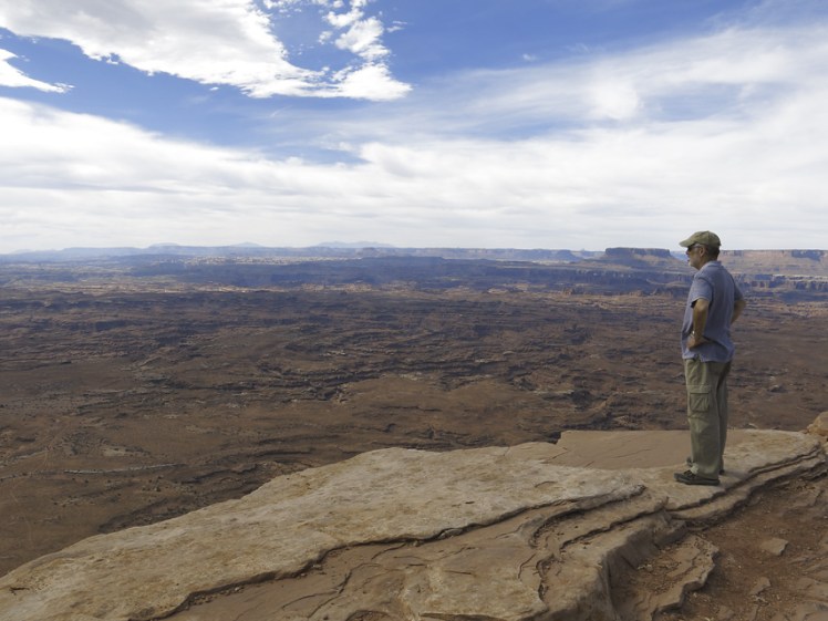
Friday, Oct. 14: In the morning we drove to the Needles Overlook on BLM land that had a view of Canyonlands National Park. We found another perfect campsite with a view and took sunset shots, including one of a rising moon only two nights short of being full:

After sunset I took a hasty selfie of us enjoying the campfire beside my camper, with the moon coming up on the witching hour. Possibly available nearby were wool of bat and tongue of dog, lizard’s leg and owlet’s wing, and even toe of frog, but eye of newt was lacking for miles, as was a cauldron…

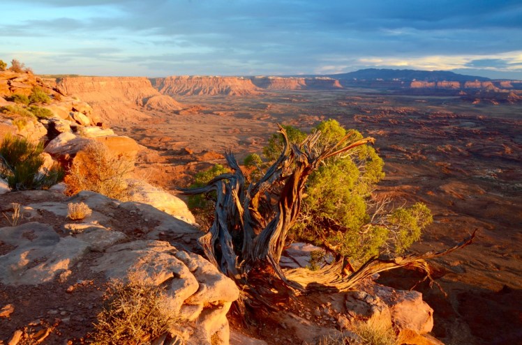
Saturday, Oct. 15: We took some sunrise shots, with one showing the tortured landscape of the ancient Colorado riverbed:


Greg and I parted ways at 10 AM, as he was to meet other friends for a week of hiking in The Maze in Canyonlands NP, and I was headed for Toroweap. I stopped at an RV park in Blanding, Utah, for the first shower I’d had in 6 days, and then drove 230 miles through Page, Arizona, until I arrived at the White House Trailhead and Campground on the Paria River, not far from the famous natural formation called The Wave, which is so popular you have to win a lottery to visit. The temperature at sunset was almost 90F.
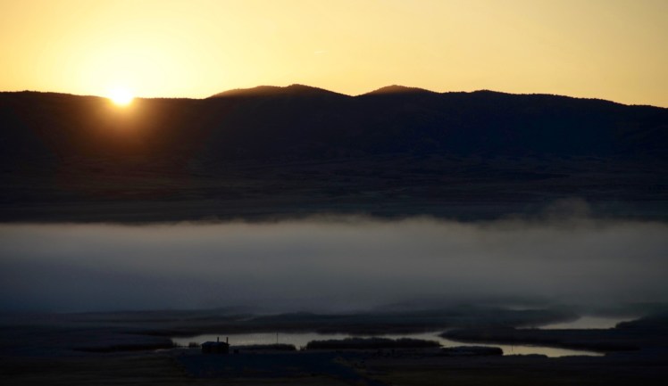
Sunday, Oct. 16: An owl woke me up early, when the temperature had dropped to 50F. I stepped out of the camper just in time to see the dawn reflecting on the clouds and the nearby butte, with the full moon setting behind it (thank you, Owl):

As I drove to Kanab, Utah, in search of a latte and croissant (meaning “crescent” in French, or medialuna in Spanish, meaning “half-moon”), I was stunned to find the full moon was still visible, a bonus due to my higher elevation. I pulled off the highway and grabbed my tripod and camera, and once again captured the full moon just before it set:

In Kanab I filled up the fuel tank for the long haul to Toroweap Overlook, about 70 miles south. That includes 61 miles of rough dirt road that is “not regularly maintained,” as per the warning signs. The Park Service website on Toroweap has this to say:
“Bring tire plugs and a portable air compressor to repair flat tires. Ensure you have enough fuel, full size spare tire, jack/lift, and owner’s manual. Tow service costs $1,000–2,000 and assistance is not guaranteed. Carry extra water, food, and warm clothing in case of emergency.”
When I was shopping in Durango the previous week I stopped to talk to a photographer who was setting up his gallery on Main Street. He had a Toroweap shot framed and mounted on the wall. I recognized the image and asked him about it. He told me it took him eight hours round-trip because he had blown a tire on the “lava rock” gravel and he just crawled out at 15 miles per hour on the return trip, hoping he wouldn’t blow another tire. It was discouraging news, as I wondered if my fuel capacity would last the trip, but he admitted that he only had 4-ply tires, whereas I have 10-ply tires that are in pretty good condition, so I resolved to keep Toroweap on my agenda. After all, it’s the most remote viewpoint on the Grand Canyon’s North Rim and “the overlook is the only viewpoint in the National Park from where the Colorado River can be seen vertically below,” and I wanted a piece of it.
The gravel road was okay for about 55 miles, allowing me to cruise at about 35-40 miles per hour. I saw a sign at the ranger station about 6 miles from the overlook that said a permit was required to camp, which one must obtain online in advance. It was news to me, but I took my chances, considering there was no other reasonable option by then.
The last three miles or so to the overlook was some of the toughest terrain I’d ever tried:


It took another hour of crawling in low 4×4 gear for me to reach the overlook, where I arrived at about 12:30 PM. I parked with my roof tilted for maximum solar power. The wind was strong and dusty, and I started writing my blog in the protection of the camper and waited for the magic hour.
A friendly camper named Dave showed up on his motorcycle. He had just come from Cedar Breaks National Monument, only about 1,000 feet higher than Bryce Canyon National Park. He said he slept with every piece of clothing he had and still “froze his ass off” in Cedar Breaks at over 10,000 feet elevation. (I was beginning to shy away from photography in Bryce). The requirement for advance permits to camp at Toroweap was news to him as well, but he said he would try to camp if I tried, too, and would “go to jail” with me if necessary, slapping me on the shoulder. I decided I would risk getting fined, kicked out or jailed for the sake of once-in-a-lifetime shots. I wasn’t keen on tempting fate by traveling on this road again.
I found a nice east view on the edge of the 3,000-foot cliff and started shooting, and continued in strong wind for about 30 minutes, ending with a satisfied selfie after sunset:

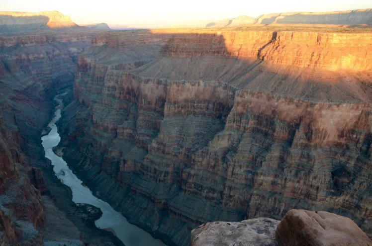

The west wind gusts were so strong that I was afraid to get close to the edge. I was also worried about the flying dust getting into the precision camera gear. My daypack actually blew over the edge, carrying my new thermal vest with it. In realtime, my brain was taking inventory of everything I was losing in that daypack as I watched it disappear over the edge. Fortunately it landed on a lower ledge only a couple of feet below, and I was able to reach down and retrieve it. But I was glad to get back to shelter and safety after the photo shoot.
I crawled back in low 4×4 gear for about a mile to the campground, which took about 15 minutes. About three or four campsites were open out of a total of ten, and I saw that Dave was already camped in one of them. I took the nearest open site I could find and just dropped into bed.
Monday, Oct. 17: I woke up in time to walk the mile to the overlook from the campground, which Dave had already vacated to avoid being arrested (“Dave’s not here“). For sunrise shots I was now looking to the west for a different view of the river and canyon. The wind was gale-force at the edge of the canyon and I worried that my camera and tripod would shake too much, since the wind frequently buffeted my body back from the viewfinder. The wind gusts were so forceful and jarring, as if invisible hands of several Toroweap spirits were taking turns pushing me. But this time the wind was blowing me back from the canyon’s edge, not towards it as it had last night, and it was dust-free, so I got my hard-earned morning Colorado River shot, albeit with windblown face:

After breakfast I headed out at about 10 AM, this time taking the gravel and dirt road towards Colorado City, Arizona, on the Utah border. A couple of miles before the Toroweap ranger station I was detained by a ranger in her pickup truck, who had stopped because a 24-inch “non-poisonous” snake was sunning itself on the road:
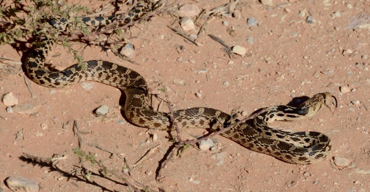
Using a stick, the ranger carefully coaxed the snake off the road, and then asked me where I had camped last night. I admitted I camped in the campground near the overlook. She told me I needed a permit and gave me a form to fill out and to pay with a credit card by fax or mail within two weeks, and she took my name and plate number. No problem, glad to pay the $10. “Have a nice day,” she said. No jail. Dave didn’t need to evacuate camp so early.
Here are some roadside pics near Toroweap, including a 19th Century instrument of torture, apparently:


In Colorado City, with a population of about 5,000, the only gas station I could find (“Deseret Service Station”) was closed permanently, apparently years earlier. The only restaurant listed in my GPS unit for the town was a pizza shop, which instinct and healthy diet told me to avoid. I had heard a little about Colorado City, so I half-knew what to expect. It had been home to a poisonous snake named Warren Jeffs, the polygamist Mormon sect leader and convicted sexual predator. His face would be suitable for a Halloween mask.
I meandered through the town, looking for a gas station and a lunch spot, and it was a strange town. The houses were mingled with industrial warehouses, with no parks or recreational facilities in sight, and no zoning to speak of. The few people I saw outside looked inanimate, or robotic. Maybe the town’s history tainted my perception, but I found it creepy, like the town in The Stepford Wives, but much less swanky.
I found a local “bistro” which turned out to be a nothing-fancy carry-out with one wooden bench inside for a sit-down meal. The personnel wore the plain dress of the local Mormon sect. I ordered a “lemon-pepper chicken wrap” to go, for $6.00. The tax was 11 percent and the tiny wrap barely had any chicken, filled mostly with lettuce and cherry tomatoes. It was tasteless, the least-value wrap I ever ate. About a mile up the highway outside of town, on the way to Zion National Park, I stopped at old reliable Subway for a $7 tuna sub, half for tonight’s dinner and half for tomorrow, each half being the size of a full meal.
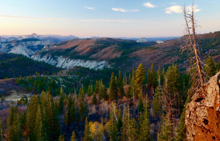
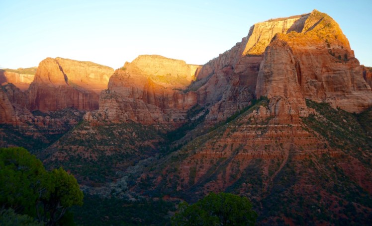
A few miles northwest of Colorado City on Rte. 59 I took the scenic route to Zion National Park via the Smithsonian Butte road, part of which was as rough as the worst part of the road to Toroweap. But once I reached the paved Rte. 9 to Virgin, Utah, it was smooth sailing, and the Kolob Terrace Road from Rte. 9 was a treat. This was the part of the park I’d never seen, and it was enchanting.
I found the Lava Point Campground sign that Greg had told me about, but it said, “campground full.” I decided to try my luck. A ten-minute drive on a dirt road brought me to the campground, which was mostly empty. Of the six campsites, only one was occupied, and the log book showed no registration since the previous day. Once again, optimism and persistence wins out. I arrived in plenty of time for sunset shots with a view of the Zion towers from the north, at about 8,000 feet, only a ten minute walk from the campground:


Tuesday, Oct. 18: At 45F degrees at about 7:30 AM, I walked to the same viewpoint for sunrise shots, and was greeted by a local resident whose breakfast I interrupted, peering at me from a colorful rock abode:


I didn’t want to fight the crowds, so I blew off the main valley in Zion National Park, which I’d photographed several times before. So, at 10 AM I departed Lava Point Campground and headed for another part of Zion that I’d never seen, the Kolob Canyon scenic drive with access from Interstate-15 on the west side of the park. It took about 90 minutes of a leisurely drive to get there. The ranger at the Kolob Canyon station told me that the Cedar Breaks campground was closed for the season, which was just as well, given that I didn’t want to freeze my shutter finger, and I blew off shooting Bryce Canyon, too. I hadn’t developed a specific shooting plan for Bryce, anyway.
The Kolob Canyon part of Zion is limited but sweet. There’s no camping allowed, and the scenic road is only about five miles long, which gave a preview of the main attractions:


The road ended at the top of a hill with a great view of the Kolob cliffs. I got there at around noon, parked for maximum solar power, made lunch, and waited for the magic hour while I updated my journal. The half-mile trail to a lookout point rewarded me with these late-afternoon shots and a view all the way south to Mt. Trumbull near Toroweap:


With those shots, and by punting Bryce Canyon, I was now free to meander for the return trip to Boise. It was a week earlier than planned, and I welcomed the lack of an agenda.
I knew that my goal of quiet camping for free that night wouldn’t come easy. I bugged out of Kolob Canyon immediately after sunset and drove north to Cedar City, where I refueled. I’d seen an intriguing feature on my Benchmark brand Utah map showing the San Francisco Mountains on the way to Great Basin National Park in Nevada. A route leading about 22 miles from Milford, Utah, included about 7 miles of unpaved road that led from Rte. 21 to the peak of the mountains, ending at a “hang-glider launch point,” which sounded interesting. I figured I could find a wide spot in the road there to camp for the night and maybe get a few good shots of the view in the morning. It took me about two hours driving in the dark from Cedar City, and the dirt road got too rough and steep to go further at night, so I pulled off the dirt road and camped at about 7,000 feet elevation.
Wednesday, Oct. 19: The next morning I got up at dawn and found the temperature outside had dropped to freezing. Out of curiosity I drove an hour up the rough, steep road in low 4×4 gear for another 1,000 feet in elevation until the road got worse than Toroweap. I could not imagine hauling a hang-glider up there on anything but a horse. Within minutes the sun rose and I got a few shots looking northeast as I headed back down the mountain:


I drove to Great Basin National Park, half-thinking I might hike and camp there (see earlier post), but it was cloudy and cold, so I drove all the way to Ely, Nevada, where I refueled and increased the pressure in my tires from 40 psi to 75 psi on the recommendation of the tire shop there: “These are 10-ply tires rated at 80 psi, you’ll ruin them and get poor gas mileage at 40 psi, especially with the weight of the camper.” Well, Big O Tires in Boise had sold me my 10-ply tires in May 2015 and recommended 40 psi with my camper for maximum comfort and utility, and they’ve held up well. So, who’s right? We’ll see. Maybe both ways are right, it just depends on your priorities: better mileage or softer ride. But doubling the pressure of my tires did give me the willies. (11/17/16 update: One month later, Big O Tires in Boise today reduced the pressure back to 45 psi after I told them of Ely’s advice. “Everyone’s an expert,” they said sarcastically.)
The Rand McNally map shows camping available at Ruby Lake National Wildlife Refuge just south of Elko, Nevada, which sounded nice, so I drove there and arrived in mid-afternoon on the west side of the lake.
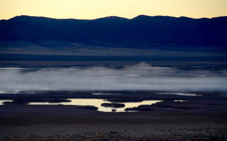
I was the only visitor. It’s a beautiful, vast (40,000 acres), marshy lake in the middle of the desert, fed by a spring that attracts 220 species of birds. Wild horses roam nearby. That afternoon I used my binoculars to watch a harrier hawk catch a fish and eat it, but it was too far away for my camera. I decided to stay two nights as long as the weather was good. Free camping was available across the road from the marsh, on the base of the mountain.
Thursday, Oct. 20: I woke up at dawn in 25F degrees outside and positioned the truck in the parking lot of the boat launch area to catch maximum light on the solar panel at sunrise, and I cooked a leisurely breakfast. Then I set my chair and tripod and long lens outside for a day of peaceful reading, photography, listening to birds and enjoying the solitude in the perfect weather with no clouds or bugs. The only sounds I heard were the flutter of small wings, ducks diving and squeaking in their bliss, and the occasional crow cawing as it flew over 100 feet above me. The previous night’s frost covered the reeds, remained through sunrise, and lingered for much of the morning, making everything sparkle.
Only one visitor stopped by for 20 minutes to walk his dog. He told me that a big storm came through two days earlier and it snowed and rained, so I had arrived at a good time. And a U.S. Fish and Wildlife ranger stopped by as part of her rounds. Otherwise, I was on my own for Wednesday and Thursday, with the following wildlife and scenes in view:


On Thursday morning I also saw two sandhill cranes fly around and land in a distant part of the lake. Their squawking was unmistakable (see my earlier post about the sandhill cranes I saw in Arizona last year at the 1,500-acre Whitewater Draw wildlife refuge, a major migration stopover for about 20,000 cranes each winter). In the afternoon I heard a lone coyote howling from the east side of the lake. The ranger mentioned that after the cranes are gone for the season (anytime now) the trumpeter swans arrive for the winter; one time she saw a coyote carrying a whole swan in its mouth after nabbing it on the ice-covered lake.
Friday, Oct. 21: I woke up to the loud “BOOM!” of one of my tires blowing out, and soon realized it was just a dream, despite also feeling the camper shaking from the force of the blowout, a residual sensation from the dream that lingered after I awoke. I stepped out of the camper, first to check the tires, which were fine, and then to see that the whole lake was blanketed with a layer of mist just before sunrise, not unlike the moor in The Hound of the Baskervilles. I could hear a lot of coyotes howling from the other side of the lake, and the crows were already cawing on my side (this morning there were enough crows here to rival the set of Hitchcock’s The Birds). I shot the scene before, during and after sunrise:

I drove down the mountain, crossed the road and parked in the lot to catch the rays and make breakfast. I didn’t stay long, since I’d gotten my shots of the place during the days before and I was hankering to discover the landscape between this refuge and the Idaho border, and to make my next campsite in time for sunset. (Especially in this region I preferred to be off the road at peak deer hazard hours). In the back of my mind I thought I might camp near Wild Horse Reservoir, high in the mountains near the Idaho border, just because it looked like an interesting area on the map. I left at about 9:30 AM and took some shots on the way north to Idaho via the Harrison Pass Road over the Ruby Mountains:


About 30 miles south of Elko I was stopped for 40 minutes while workers cleared the wreck of a truck from the side of the road. A Nevada Transportation Department worker there told me that the accident occurred shortly after 5 AM, and the driver was in the hospital, and they were just getting around to clearing the road for the last hour. “I think he fell asleep while driving, and I don’t think he was avoiding a deer, because drivers of big trucks like that don’t care about deer.”

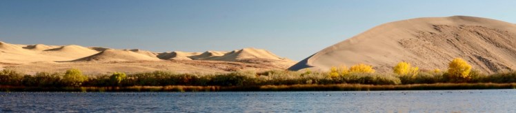
The manmade Wild Horse Reservoir didn’t grab me because the dammed recreation area was too artificial and the nondescript scenery was washed out with the high sun, so I decided I’d continue to Idaho and camp at Bruneau Sand Dunes State Park, just south of Mountain Home Air Force Base (hopefully far enough away from sonic booms and other jet noise). I’d heard about the park, that it was cool to check out the dunes and the telescope in the onsite observatory. I arrived about 4 PM, and I was bummed out that the observatory was closed, but the park has a pier on a lake with abundant of wildlife, so I grabbed a nearby campsite and shot birds and landscapes at low sun:


As I was leaving the lake’s pier I ran into the couple who appear in the photograph above, and I gave them my card, offering to send them their photo if they contacted me.
All in all, I was satisfied with the photo ops, but the closed observatory and the campground were disappointing. The campground was well maintained, but it had enough flies to supply the set of The Amityville Horror, and I’m glad I got there at 4 PM to reserve a site because Friday night was full of families with kids, all campsites were full by sunset, and it was noisy until 1 AM, despite the 10 PM “quiet hour.” I finally had to use my earplugs, quite a contrast to the peace of the Ruby Lake wildlife refuge. What was I thinking? After all, state parks located only an hour from Boise will be full on beautiful weekends, of course.
Saturday, Oct. 22: I awoke to a loud “PFFT!” of an electrical explosion, and I looked up from my bed and saw smoke rising from the electrical box on the outside of my camper. It was my camper’s first catastrophic power outage! I was quickly relieved when I realized that it wasn’t possible to see the outside of my camper from my bed inside, and I wasn’t plugged into any AC power outlet in the campground, and I didn’t have an outside electrical box, so it was obviously another dream. Halloween nightmares were coming to me early.
On the upside, these unusual, startling dreams were occurring just in time to wake me up for sunrise photography (was that really an owl that woke me up at White House Trailhead and Campground in Utah on October 16?). I quickly got up, just in time to see the eastern horizon start to turn pink, and I drove from the campground to the observatory park only 5 minutes away. I was walking quickly from the parking lot to the lake’s pier, while laden with all my camera gear, but I started to run as the sunrise looked more imminent:

When I got to the pier I stopped dead in my tracks, seeing the dark, hooded, almost menacing image of someone, or something, sitting at the bench on the pier, like a shadow ghost. I quickly took the last shots of my road trip before the sun appeared:
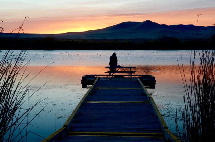 The increasing clouds after shooting this scene made it apparent that the morning would not be conducive to any more photography. As I packed up my gear I chatted with Eric the Friendly Ghost (his hoody was a pale blue in the sunlight) and I gave him my card. I told him I was disappointed that the observatory was closed, and he agreed, mentioning that he’d seen Saturn’s rings there in a previous visit. Then he told me that an observatory official advised him that day that a catastrophic storm in September had caused an electrical power outage (“PFFT!”) at the observatory, which remains without power to this day. I later found their Facebook timeline entry of Sept. 28:
Bruneau Dunes State Park
September 28 at 8:45am ·
“Due to a major storm this past weekend we have lost power to our Observatory and will not be offering an Observatory program or night sky viewing…”
I drove back to Boise, looking forward to the next spooky phenomenon that might come my way, as long as my truck’s tires and camper’s electrical box remain sound.
Happy Halloween!
p.s.- Eric contacted me three days later, and I emailed him the above sinister image, as well as the less colorful version below, which, with one simple twist, appears more benign:

But just as you’re relaxing, an even scarier image looms…

You have interesting dreams!
LikeLike