After a Boise winter with record snowfall I wanted a break from the cold and decided to try my photographic luck with a spring road trip to the Utah and Arizona deserts. I’d heard that some years produce just the right volume, frequency and intervals of rain that make the desert wildflowers go crazy. This spring California was blessed, so I was hoping that a “super bloom” had ventured into southern Arizona, too. I also wanted to test my second solar panel that I installed on my camper roof four months earlier, one that tilts to the angle of the sun. Slowly, my “Blue Meanie” rig was taking on some green features.
On Saturday, March 4, 2017, I departed Boise at 9 AM and headed for Great Basin National Park in Nevada, where I planned to camp overnight before heading to Zion National Park, where I’d reserved a campsite for four nights. After numerous trips south I prefer the relaxed desolation of the Nevada route to the nerve-wracking congestion of endless Salt Lake City. My Audible Books for this leg of the trip was Steinbeck’s Travels with Charley, which I’d read decades ago but had mostly forgotten. Featuring a French poodle and a truck camper that Steinbeck named Rocinante, it’s one of those inspiring tales involving a road trip with an animal, like the movie Harry and Tonto, which I also love. One of my fantasies is to have me and my cat traveling together in my truck camper, as others have done. Some day I’ll get a cat. Dog persons often suggest I get a dog (“ever hear of a seeing-eye cat?”) but I’m a cat person and would rather choose the rebellious, less commonplace option. And cats don’t bark. (Neither did Charley, but Steinbeck claimed he was an exceptional dog with “Continental manners” not often found in the U.S.)
It was raining in Boise when I left, but it cleared up by the time I turned south at Twin Falls for the Nevada border. I arrived just before sunset at Great Basin NP, where one campground is open year-round. I didn’t have much time there, as I wanted to get to Zion well before sunset in order to scope out the hikes to get the best light for photos. My previous visit to Great Basin is described in another blog on this website.
I got to my Zion campsite at around noon, studied the map and boarded the shuttle to the trailhead for Angel’s Landing, which is probably the best known trail in Zion aside from The Narrows. The park’s brochure mentioned that private vehicles can do the scenic drive through the canyon until March 15th, which I would have preferred, but a ranger explained to me that after studying visitor data, the park decided to require taking the shuttle on the weekends until that date. I wasn’t surprised, as I’d considered myself lucky to have found a vacancy in the park on a weekend at this time of year. As it was, I had to change campsites within the Watchman Campground in order to stay four nights. I had visited the park in the early 1980s when it was first-come first-served, with no problem camping, but Zion now had a reputation for being overcrowded, and online reservations are now required well in advance.
The wind was so high on the trail that I decided, among other deterred hikers, not to climb the narrow ridge to Angel’s Landing lookout. Instead, I hiked a little further to Scout’s Lookout. While I was shooting the scenes some wildlife showed up, a welcome addition since the high-contrast lighting in the canyon made landscape shots difficult.
I did another hike the next morning (Sunday) to shoot at sunrise, and then spent two days (Monday and Tuesday, March 6-7) shooting at sunrise and sunset around my campsite and filling the bulk of the day with a couple of books: Beyond the Wall by Edward Abbey and Walking it Off: A Veteran’s Chronicle of War and Wilderness by Doug Peacock, both men better known for The Monkey Wrench Gang, Abbey’s fictional story of some eco-saboteurs that I’d heard about but never read (Peacock was the model for the Hayduke character). I was headed into their legendary territory to shoot landscapes in southwest Arizona near the Mexican border and around the Utah-Arizona border area, so I wanted to be aware of some issues surrounding that environment, such as their reason for abominating the Glen Canyon Dam, for one thing. I’d known the dam was destructive, but didn’t know to what extent, or what the current problems are, or much of the eco-activist history behind it.
In the summer of 1990, some young environmental advocates from Oregon who’d done some tree-sitting in redwood country did a road trip to DC and made the news. They were bound for a protest rally over the destruction of old-growth redwood forests. It was the summer when the Earth First! activists, inspired by The Monkey Wrench Gang, had organized a campaign called “Redwood Summer” after becoming known, at least to law enforcement, for shenanigans like painting a fake crack in Glen Canyon Dam.
Earlier in 1990, as I’ve since read in one of the links I provided above, one prominent activist in California had been severely injured while en route to a protest rally, and the FBI apparently attempted to frame the victims by charging them with transporting the pipe bomb that blew up their car, with no attempt to trace the actual bombers, and later lost a lawsuit filed by the victims. Apparently, FBI had been following Earth First! since 1981 and had failed in a sting operation in 1988 in which they tried to recruit non-violent Earth First! activists in a conspiracy to blow up nuclear power plants. Edward Abbey himself was against any injury to people and against destruction of property.
Anyway, here are shots I took in Zion, a few good ones, but more just for fun:


I decided to leave Zion a day early and forfeit the camping fee for Wednesday night. The park was just too crowded with people who weren’t aware or didn’t care about the park’s rule against excessive noise, foreigners and domestic tourists alike. Barking dogs and late-night rowdy partying in a national park especially get my goat. While hiking the Angel’s Landing trail I finally put my finger to my lips to try to shush some loudmouth foreign-speaking hikers, but they ignored me or didn’t pick up on the universal sign-language. I finally had to use earplugs due to some young late-night party animals in the campsite next to mine, who couldn’t stop gushing and laughing about their Zion hikes until well after “quiet hour.” I got sick of it and opted instead to check out the Vermilion Cliffs National Monument to the southeast, especially as I was satisfied with the shots I’d gotten in Zion already.
Specifically, I’d seen a recent photo posted on the internet of the remote White Pocket area of the Vermilion Cliffs and wanted to get some shots of my own. I’d passed the cliffs several times over the decades but wasn’t aware of their Monument status and had never entered the area, as it looked too remote, bleak and forbidding from Rte. 89A that spans the southern edge of the area. My photographer friend Greg Jahn told me a little of how to get to White Pocket, and showed me nice shots he took there, which further inspired me, but warned that much of the way was “technical four-wheel driving” with a risk of getting stuck in deep sand.
In hopes of getting a good map of the area I headed to the BLM outpost on the northern Rte. 89, about half-way between Kanab UT and Page AZ and about 10 miles beyond the turnoff to the dirt road called House Rock Valley Road that leads south into the Vermillion Cliffs. I took a short detour into Escalante National Monument to the north of Hwy. 89, to a place marked in the Rand McNally atlas as “Paria Movie Set” with a picnic table, which looked intriguing for a lunch break.
Well, the ghost town that served as the model for the movie set for The Outlaw Jose Wales had washed away in floods, and the set had burned down, so that was a letdown, but the picnic tables were there and the roadside environment was impressive even at high noon, the worst time to shoot such scenes (the photo in Wikipedia link above is far better):


I got to the BLM office for some backroads advice, only to find it doesn’t open until March 15, so I decided to take my chances and head down House Rock Valley Road to search for the turnoff to White Pocket. House Rock Valley Road is rough, full of deep tire tracks in dried mud, and I never saw any turnoff into the wilderness that looked promising, so I gave up in favor of doing more research and searching for White Pocket on the return trip to Boise from Arizona. I found a nice BLM campground that was quiet and free, the best kind. I popped up my new solar panel that I’d rigged with gas struts and pulleys for an adjustable tilt, deployed my self-supporting hammock, and got back to my book…


Also in the campground was a self-described “hedonist” couple, Eric and Catherine of France, with their Unimog-type camper (Catherine moved out of camera range):


We exchanged cards. Their English was as bad as my French, so we muddled through the communication barrier with some Spanish thrown in. They’d spent the last five years on a road trip all over South America, North America (including Alaska), and Central America. One of my dreams is to do a road trip like that and I asked them what their Mexico experience was like, as that leg always seemed to me like one to avoid, given the stories of corruption and crime with which my former job’s focus and filters had succeeded in packing my brain for over 26 years. They told me they avoided the crime-ridden border area south of Texas, New Mexico and Arizona and instead drove down the Baja Peninsula and took a ferry across the Gulf of California, picking up on the mainland again to head south. They said the Mexican state of Chiapas was the dicey one in their travels, but they got through fine, and recommended Mexico in general. Also contrary to my preconceived notions, even food-borne illness was not a problem for them in Mexico. One thing that Catherine emphasized repeatedly: Refuse to comply with any shakedown for money by the Mexican highway cops. They’ll let you go eventually, and your reputation for intractability will precede you for the rest of your journey, and you’ll save money.
It turned out that Eric and Catherine had just returned from White Pocket, and their map was better than anything I’d seen so far, so I took a picture of it. It showed me exactly how to get there, and they’d marked which backroads to avoid. But it was getting late in the day and I was due to meet up with my friend Bob in Phoenix the next evening, so I resolved to camp for the night and head to Phoenix as planned, and try White Pocket on the way back, when I had more time to explore and do justice to the photogenic landscape I was promised.
The drive to Phoenix was long and uneventful, so it was a good time to start my new Audible Book titled A Short History of Nearly Everything by Bill Bryson, which I highly recommend, especially with his British accent and dry humor (A Walk in the Woods was my intro to Bill decades ago). It really brings home how short and tenuous human life must be viewed in the context of geological time and cosmological events. For instance, a visit to Yellowstone necessarily requires one to accept the fact that the super-caldera on which the park sits can blow at any time without warning and with far greater force than any volcano in recorded human history, as it has every 600,000 years or so. The last blast happened about 600,000 years ago and covered Iowa with its ash a foot deep. And lest you become complacent by steering well clear of Yellowstone: Contrary to the popular belief that abundant and vigilant astronomers manning telescopes across the globe can give us sufficient warning, an asteroid large enough to destroy life on Earth as we know it can hit us at any minute. Yeah, thanks, Bill. Pass the wine.
As I drove and listened to Bill I noticed that I-17 between Flagstaff and Phoenix was in really poor condition, much worse than the highways in Idaho. It’s a poster child for the dire state of U.S. infrastructure. And I didn’t recognize Flagstaff, which I’d last seen 30 years ago. Back then it was a sleepy little college town with funky coffee shops downtown. Charming had turned into bustling and sprawling with chain stores and suburbs.
Anyway, I stayed with Bob on Thursday night and played some pool at his favorite watering hole. On Friday morning I called BLM from his office in search of a map of Vermillion Cliffs and White Pocket. To my surprise BLM said they had no such maps and sent me to a commercial store called Wide World Maps in the city, which also didn’t have a map nearly as detailed and useful as the one Eric and Catherine have. I gave up and resolved to rely on the photo I’d taken of the French couple’s version, which cost me zero.
I headed for Organ Pipe Cactus National Monument around noon, arriving at about 3 PM. After setting up my hammock I spent the remains of the day waiting for the magic hour for shooting. I started reading Dead Wake: The Last Crossing of the Lusitania by Erik Larson, a true and fascinating story of the triumph of bureaucracy, misguided trust in authority, and human nature over logic, clarity, and rational, independent thought, resulting in a disaster that was arguably inevitable. The background of that event is an example of why history repeats itself even if one studies it. The syndrome is disturbingly applicable to current political developments in a nuclear world, so dissent and non-violent resistance is even more imperative today. But I digress. Pass the wine.
Organ Pipe was a lot more crowded and warmer this spring than when I last visited in November 2015, but I got a decent campsite easily, and Bob arrived there at around 10 PM. We’ve been friends for over 30 years so we spent the weekend talking about all sorts of things (short histories of nearly everything). He’s a raptor biologist who works in endangered species policy enforcement for the U.S. Fish and Wildlife Service, in liaison with the Federal Highway Administration. One topic of our conversation included the huge population projection for Phoenix in the next 20 years. He wonders where the water will come from, considering the city’s current size and the paucity of water resources already apparent, including the depleting reservoir at Glen Canyon, for example.
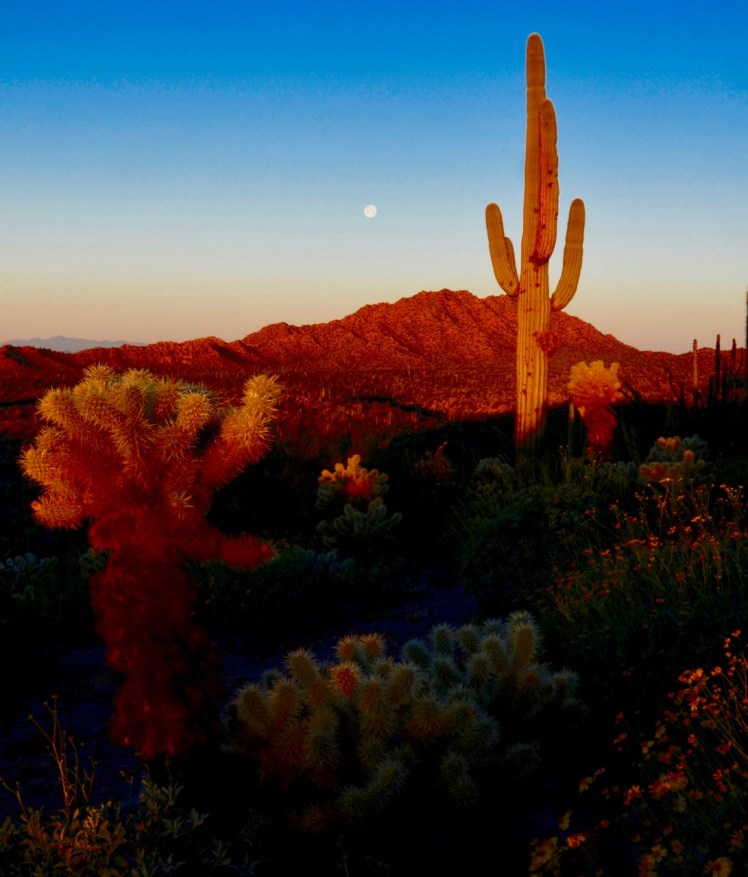
The moon was full and the spring bloom was well evident. Although a botanist might not have identified a “super bloom” in the area, the ocotillo was sprouting its leaves and red-flowered tips in glorious fashion, and there was plenty of other flowering ground cover in this Garden of Eden:


On Friday night I dreamed that Reince Priebus tried to bring me back into what he called government service. He summoned me into his office and handed me a package, telling me to fly to Los Angeles, where another government employee would meet me at the airport and receive the package. He told me I didn’t need to know the contents of the package, so I refused to accept it, telling him that I knew my rights and obligations as a former government employee and a private citizen. I went to a bar across the street, and as I was drinking my cocktail a benevolent-looking stranger walked up and sat beside me, telling me that he was the boss of the officials who’d cooked up the plan that I refused, and he told me not to worry, that he would talk to them and “fix things,” and that it was okay to do as I was asked, without fear. “Trust me,” he said.
I drank my drink and again refused. I woke up thirsty at about 2:30 AM and reached for my Camelback.
I needed a hike. Late Sunday morning, before Bob left for Phoenix, we hiked the 2-mile nature trail that leads to the top of a hill with a nice overlook. The sun was too high for the best lighting for photos, but the surroundings were still charming:


On my last morning there, Monday, I woke up later than planned and quickly geared up for the hike up the desert trail to the top of the nearby hill, where Bob and I had been the day before. I almost ran up the hill in an effort to beat the sunrise. I made it to the top in time, but in my haste I brushed against a cholla cactus as I was setting up my tripod, and stepped on some cholla pods, too.
Words of advice: Don’t touch a cholla cactus, not even lightly. There’s a reason it’s called “jumping cholla,” the plant world’s rattlesnake in the Garden of Eden. The spines easily penetrated my pants and lodged in my thigh, which magically detached a fist-size spiny pod from the main plant, which clung to my pants as if it were an alien life form, and a pod also lodged securely in my shoe. I used a couple of sharp rocks as forceps to remove the prickly pods, leaving a few embedded spines behind, but the barbs on the spines made it impossible to remove them completely from my thigh without taking off my pants. Since the material of my pants was rubbing the spines in my thigh, aggravating the pain and embedding them further, I “dropped trou” on that hilltop, where I was still alone, fortunately. But I didn’t have time to complete the removal operation, as the sunrise was too imminent, so I paused in my surgery and concentrated instead on composing shots and selecting the f-stop and exposure compensation, etc., with my pants around my knees, until after the “magic hour” light had passed about 15 minutes later. Any passerby surely would have been astonished, but I got the shots I wanted:


Later that morning I packed up and headed to Saguaro National Park on the western side of Tucson, as I’d never seen it. On the way I stopped for lunch at the top of Kitt Peak near the observatory, as I’d never seen that, either. I got to Saguaro NP around noon, and did the dirt-road loop that took about 20 minutes, but I wasn’t impressed. Organ Pipe was a lot lusher, looked much healthier, and has plenty of giant saguaro of its own, so I didn’t stay to explore further. The volunteer in the visitor center told me about an overlook outside the park on Gates Pass Road with views east to Tucson and west to Kitt Peak, so I headed there. Being so close to Tucson, the overlook is very popular, and was soon crawling with gawkers:


After camping in a barren no-man’s-land (a BLM site?) about 10 miles west, I returned to the overlook on Tuesday, March 14, for some sunrise shots toward Kitt Peak:


March 14, 2017: Pi Day, Tucson, AZ. At mid-morning I headed to the home of old friends Bill and Georgette who’d bought into the Saddlebrooke retirement community north of Tucson. (They served me cherry pie a la mode the first night to celebrate Pi Day.) Saddlebrooke is upscale, with a minimum age requirement of 50, and my friends bought a small but beautiful house with a view and a guest house. This environment even attracted a great horned owl, which sleeps in the crook of branches in a tree around the corner from the house. Every night the owl starts its hunt for food by perching on the neighbor’s roof and hooting, which I saw and heard. Now I wish I’d had my camera handy for even one shot of the owl in its daytime hammock in the tree, more proof that I must always “carry.” At least Bill kindly provided a photo he took a week later, filling the void:

That night I dreamed that I toured a wine warehouse the size of a city block, and as I was searching for my favorites I ran into an Italian wine merchant couple. They were minding their own section of the warehouse, and when they saw me approach, the beautiful woman plucked a bottle from the rack and handed it to me for free. In a thick Italian accent she told me it was a yogurt-based beer, not a wine, so I opened it and tasted it and was impressed, so I chugged it all down and bought a case from them. I woke up really thirsty at about 2:30 AM, but it was a better dream than the previous one at Organ Pipe.
While staying in Saddlebrooke we toured the impressive Biosphere 2, just a few miles north. I also played pickleball for the first time (poorly) and enjoyed it. I’d heard of the game about two years earlier and was interested in trying it out as a fun but knee-friendly alternative to tennis and racquetball, which I miss. It turns out a pickleball facility is being built in Boise (information link), but in a congested area 10 miles to the west of my house. Supposedly it’s the fast growing sport, so I imagine it’ll pop up near me soon.
On Wednesday I walked into the breakfast room and Georgette advised me of the disturbing news that one of her two cats had gotten out during the night. At first I feared that I was to blame by leaving the dining room door open, but no, Georgette had left their bedroom door open, and Ralphie not only got out, but obviously went hunting and returned to the bedroom to leave a present in the form of a half-dead baby bird, and then went out once again and didn’t come back. All day Georgette called for him, worrying that the big owls and coyotes were known to prey on cats like Ralphie. Finally, that night, the next door neighbor alerted us that Ralphie was on his roof and apparently couldn’t come down. Georgette got a ladder and grabbed Ralphie at the edge of the roof, but lost her balance and fell backward onto the ground, taking Ralphie with her. The fall didn’t hurt Georgette, but Ralphie grabbed on for dear life and left deep claw wounds in her arms before bolting, and once again kitty was loose. Ralphie spent the remains of his liberty playing in the back yard, coyly refusing to be coaxed inside. The kitty saga finally ended when hunger took over, as one might expect: Bill placed a bowl of food just inside the door, which did the trick. Ralphie’s dissent dissipated.
On Thursday I headed north towards Sedona, taking the scenic route and bypassing Phoenix. I camped for free on National Forest land just north of Payson, and headed out early the next morning. Sedona was packed with tourists, and I’m glad I didn’t try camping around there, as I would have been out of luck. The red rock scenery is stunning and Sedona is very upscale, but I breezed through as quickly as possible. I was on a mission to shoot White Pocket at sunset and had no interest in Sedona except to remind myself of the passing scenery and confirm my suspicions that I could never afford to live there.
But I did stop at Montezuma Castle National Monument, which preserves ancient cliff dwellings from 1150-1400 AD. You can see the exterior of the ruins, but tours of the interior were discontinued in the 1950s because of the risk of damage. Now there’s a diorama on the tour trail that shows the interior of the “castle,” which is impressive considering the deceptively modest exterior (I loved the landscape below it, too):


I made it back to the Vermilion Cliffs National Monument in good time, by early afternoon. I arrived at the turnoff for White Pocket and spent the next 1.5 hours driving in “technical” 4×4 mode, trying not to get stuck in deep sand, referring to my photo of the French couple’s map that I saved on my laptop. It was a taxing and tense run, but well worth it. In late afternoon I made it to the sand parking lot at the end of the road, where a few others were parked to camp. I was finally at White Pocket, a brand-new venue for me:

I stayed for two sunsets and two sunrises:


")


White Pocket is a photographer’s paradise and it was thick with shutterbugs and photography instructors who sometimes wandered into my frame. My first sunset and sunrise there were clear and bright, but clouds had moved in by Saturday afternoon. By noon on Sunday I was finally alone, and the clouds were getting thicker, and I was concerned that if it rained that night I wouldn’t be able to get out, especially with no one else around to help. On Friday, one couple driving a Jeep had already gotten stuck in the deep sand in the parking lot and another visitor in a light truck had to pull them out. Now I was alone in a possibly upcoming storm, which, according to the BLM signs, would render the roads “impassable,” which the French couple with the Unimog had confirmed to me, which was pretty damning evidence. If they couldn’t get through these roads after a rain in that moonscape-crawling behemoth, what chance would I have?
It’s amazing, but I actually had internet service in that remote White Pocket parking lot, and I got an email from Gordon that NOAA was predicting rain for the Canyonlands area, so I decided to leave. I was pretty satisfied with the photos I’d gotten so far, anyway. I packed up and headed out for the one-hour technical 4×4 drive back to House Rock Valley Road. Three or four times during that hour I was really sure I would bog down in the sand and would have to wait for help, but I made it through.
Only one other 4×4 was headed the other way, and he made room for me to pass. So, at least someone behind me would have had to help me get unstuck if he wanted to get out as well. And besides, I wasn’t on a schedule, so getting stuck would only be a temporary inconvenience, for me at least. But no sense in sitting around in the rain, tempting fate, burdening a good samaritan, and being denied my vocation.
It was after 6 PM when I hit Rte. 89A and turned east towards Page, so I looked around for dirt roads to take me away from the highway for a quiet place to camp. I passed one that looked promising, with a closed gate, but closer inspection revealed the gate was unlocked, so I drove about a mile and a half back north toward the Vermilion Cliffs and found a fairly level pull-off at the base of a hill. I pointed the truck to the east and raised that solar panel to catch the first light of morning, and settled down for the night. This whole area is BLM land and free to camp, and I was in the middle of nowhere, listening to coyotes and owls, which I’ve come to equate with peace and security.
The next morning I shot the scenes around me at sunrise:


I stopped in Page, Arizona, for gas and food, and headed to Valley of the Gods in Utah. I passed the Navajo electricity generating station, which was pretty jarring to see:

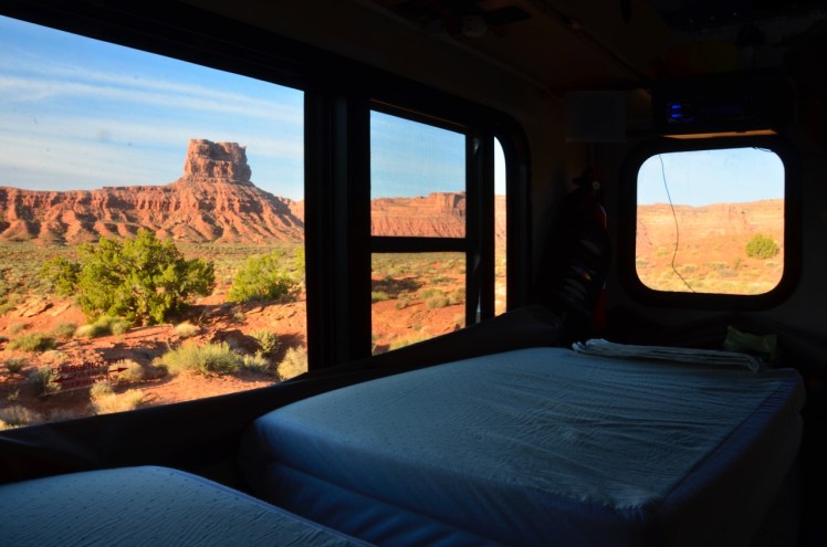
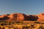
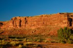
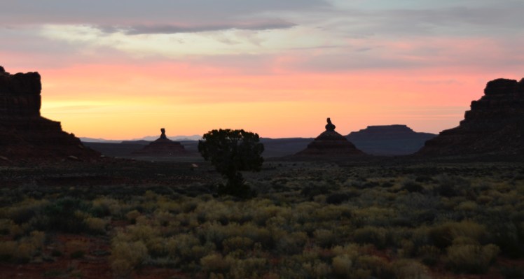
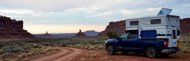
In the Valley of the Gods I found a suitable roadside campsite and took some shots at sunset and at sunrise the next day:


On Tuesday I moved to another campsite across the valley, where I got some sunset shots in a 270-degree panorama. One day I’ll stitch ’em together when I can afford Photoshop:


Wednesday morning was so overcast that the only art shot I got was at pre-sunrise before the sun was completely obscured by clouds, and I should have used a graduated neutral-density filter:
Later that morning, the artless but obligatory shot of Blue Meanie in its preferred element:
This is BLM land and the camping is free, which is nice, especially since the campsites are well spaced for privacy. But I did notice something that I had not encountered on this trip before: Bugs, including mosquitos. Not many, but nonetheless present and annoying when you step out of the shade. They gravitate to your sweaty forehead in the sunlight. I wonder if they were a result of the substantial creek running through the valley, which was running low but wet. There was no sign of cattle having grazed here, which would have been my first guess as to the culprit. I was reminded of how bug-free the Sonoran desert was in Organ Pipe, with no cattle and no creek.
I hung around until mid-morning, reading Dead Wake, and tried to call Gordon, but signal strength was too spotty. After trying various high points in the landscape I finally had to drive a half-hour north to Bluff, at the southern end of the Comb Ridge geologic formation to which Ed Abbey and Doug Peacock had often gravitated in order to renew their spirits. I picked the first “coffee” listing under the Bluff-area restaurants displayed on my GPS.
It was 11 AM and I pulled into Comb Ridge Bistro & Espresso Bar to make the call to Gordon, since signal strength had picked up. Another Toyota Tundra 4×4 packing a Four Wheel Camper “Hawk” model like mine sat in the parking lot, and the driver wandered over while I was talking with Gordon on my phone in the driver’s seat. “Just checking out your camper,” he said to me, and I gave him a thumbs-up. (I’ve gotten a lot of interest in my flip-up solar panel, and I’d forgotten to pull the curtain in the camper window, so he was getting an eyeful inside and out.) I admired a tidy and efficient-looking Scamp trailer in the parking lot, and watched a Toyota Tacoma 4×4 pull up beside me and empty itself of three fit-looking, latte-craving coeds dressed in pajama shorts and sporting hippie braids and nose rings. A grizzled, white-bearded explorer wearing an Australian outback hat wandered in from an apparent month in the wilderness wrestling gila monsters. A young Patagonia-clad hiker couple were relaxing on the porch, sipping coffee and typing on their MacBook Air laptops. I’d arrived at the right place.
Gordon was having electrical trouble with his truck and we decided to cancel our rendezvous at Needles Overlook in Canyonlands, much to my disappointment, as I’d been hauling two bundles of firewood since Organ Pipe and had plenty of wine and hummus for a marathon discussion of… Life, liberty and the pursuit of happiness, as usual. I was now out of sorts, wondering what Plan B would be. It was overcast, threatening to rain on my photography plans, and I didn’t relish camping alone for the next two days in these conditions, just waiting for Friday, my planned day for the drive home.
I strolled into the bistro for a latte, and the barista persuaded me to have an early lunch with their smoked salmon salad, which I ate with the latte, and packed a home-made pecan pie to go. I’m here to tell you, that was the best salmon salad and latte I’ve ever had. That place is a gem, an oasis in the desert that boosted my spirits. I told them I’d mention them in my blog, and I’ve now done as promised. As Gordon put it, “It’s where the yuppies and the hippies meet up.” Don’t miss it!
The oasis of Comb Ridge put my mind to rights, and I headed north, homeward bound. About an hour later I passed through Monticello, UT, and of course stopped at the Peace Tree Juice Cafe and picked up a Thai chicken wrap to go (for dinner) as usual. It’s another oasis, by the way, and it opened a branch in Moab, where it’s much less of an oasis.
I drove through the Wasatch mountain pass and arrived at Utah Lake State Park in Provo at about 5 PM, where I planned to camp for the night. A sign at the entrance to the park noted that the campground was closed until March 4th, so I paid the $5 entrance fee with a credit card in the automated kiosk and happily entered, as it was now March 22nd. I was looking forward to an absorbing night of Dead Wake.
I drove to the campground in the park and found it was closed with a barrier. I drove around elsewhere in the park but found no alternative. The park has a boat harbor and is very much geared to day fishing, with abundant “no parking” signs. I pulled up to the maintenance facility and asked a couple of workers if I could just park overnight in their lot, given that I’d paid my entrance fee a few minutes ago and was misled about the campground’s availability. They agreed that the sign was misleading, but of course they said no, and suggested a commercial campground just up the street for $30 per night. I’d seen that place on the way in and it looked overcrowded. I thanked them and exited.
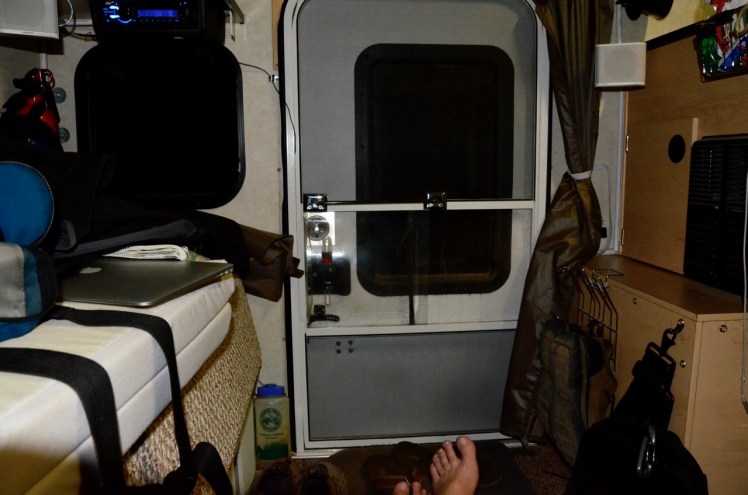
Outside the park I drove down a lightly used side road called North Boat Harbor Drive until I saw a secluded lot surrounded by trees, which were still bare of leaves but provided a psychological divide from the road. There was no sign prohibiting overnight camping. I pulled into the lot and positioned Blue Meanie in the far corner facing the setting sun. I tilted both the rear solar panel and the whole roof forward to maximize the last rays of the sun on both panels. My plan was to sleep on the lower bunk with the roof locked down, to appear to be parking rather than camping, and hope that the area was not patrolled by authorities or monitored by property owners. Previously I’d implemented such security measures only in backcountry grizzly territory where soft-sided camper walls were not prudent. I’ve never felt the need to be armed, despite friendly advice from several former colleagues with badges.
At dinnertime inside my camper, now with the roof locked down, the curtains and blinds drawn, and the overhead lights off in favor of a less-noticeable headlamp, I ate my Thai chicken wrap with a glass of wine and NPR news on low volume, and I listened intently for the approach of any vehicle. The sun had set and the rain started to fall and patter on the roof. My dual solar panels appeared to have charged the camper batteries to full capacity during today’s journey, in spite of the sun being obscured by rain clouds for most of the day. The upgrade to a second panel was well worth the expense and hassle.
So far, so good, but vigilance was still in order. I couldn’t see outside, and every car that I could hear approaching my parking lot with its headlights splashing across the curtains, about every two minutes, was a potential torpedo to my secure and peaceful evening. I needed to hear that torpedo miss its mark and continue down the road.
My friends and I once joked that a periscope in the camper’s roof would be a useful factory option, to turn my camper into a warm and comfortable blind for wildlife viewing. In my current situation I could check for approaching authorities and shut down all light and sound inside my camper in case of an impending investigation. Especially seeing the roof dropped down and locked in highway mode, anyone would assume the driver was delayed elsewhere rather than hiding inside and camping illegally. As a threat, Blue Meanie was more the Yellow Submarine and less of a U-boat. That’s my story and I’m sticking to it.
Undisturbed by destroyers, I read Dead Wake until 10 PM to the light of one ceiling LED, minimally visible from the outside through the curtain material. Several surface vehicles passed but none stopped to probe the depths. Blue Meanie was in low-profile mode, with roof and periscope down and a hushed, now-cramped cabin, hugging an obscure section of the harbor floor until the safety of morning would allow a surface breakfast with raised roof and open curtains. The precious cargo of three weeks of photographs was securely hoarded in the flash drive of my laptop next to my bunk.
I bedded down to the sound of the rain and the reassuring hoot of an owl, the sting of the wasted $5 park entrance fee somewhat mitigated. I felt certain I’d remain under the radar, slip out of the harbor undetected and be home in Boise by happy hour the next day, with no parking citation, nor obligation to search for a campsite in the rain at midnight, nor $30 fee for the horrors of a noisy and overcrowded RV campground. I may have been committing a civil infraction, depending on the ownership of the lot. I think it was state land, so I wasn’t trespassing on private property. Even with no sign posted, maybe overnight parking there was against Utah State Park Authority policy. But in this case it seemed better to keep a forgiveness plea ready in my pocket rather than show my hand with a plea for permission. In my experience it’s been a wiser course of action more often than you might think.
CREDITS AND ACKNOWLEDGMENTS:


Gorgeous photography and very engaging blog text. The White Pocket photos in particular are stunning.
LikeLike